Apr 27, 2017
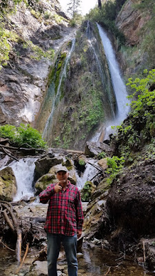
Limekiln State Park
Limekiln State Park is located in the Los Padres National Forest on the Big Sur Coast. It contains four lime kilns from an 1887-1890 lime calcining operation, plus a beach, redwood forest, and 100 foot Limekiln Falls. The Park is located 2 miles south of Lucia on State Route 1. The 711 - acre park was established in 1994. We are Camp hosts at Limekiln this summer.
Aug 20, 2013
Eagle Lake, Eagle Falls and the Desolation Wilderness
The hike to Eagle Lake into the Desolation Wilderness is 2.64 miles round-trip the elevation change is 664 feet. The picture of Emerald Bay is taken from the top of Upper Eagle Falls.
Jul 15, 2013
Emerald Bay Lake Tahoe
Emerald Bay Beach – a National Natural Landmark with 360 degree views that encompass Emerald Bay, Fannette Island, and Eagle Falls. This dramatic bay setting has been called one of the “most photographed places on earth.The bay can be accessed by watercraft, or by a pleasant, moderate Vickingsholm hiking trail which is a one-mile hike (with about a 450-foot elevation change) that leads to the beach.
Jun 6, 2013
Lower Echo Lake
Lower Echo Lake and Marina is located at Echo Summit about 4 miles east of The KOA just off Highway 50. Just across the dam on the lower lake the Echo Lake Rim Trail leads to the upper lake. This trail splits off at its beginning and is part of the Pacific Crest Trail (Tahoe Rim) and leads to Desolation Wilderness.
May 31, 2013
Hope Valley Wildlife Area
Picketts Junction - approximately 12 miles south of South Lake Tahoe on Highway 89 at the junction of Highway 88 in Alpine County.
Apr 30, 2013
Lake Baron
On the banks of the Upper Truckee River, and a short walk from the Lake Tahoe KOA is one of Tahoe's little known gems. Tahoe Paradise Park provides
numerous ways to spend the day. The upper section of the park holds Lake Baron, which provides fishing
opportunities as well as excellent calm water for skiing or wakeboarding.
The lake is only one mile around and has tennis courts and a clubhouse
which features a wading pool and full size roasting spit.
Nov 2, 2012
Pyramid Lake and The Truckee River
Pyramid Lake covers 125,000 acres, making it one of
the largest natural lakes in the state of Nevada. It is also the
biggest remnant of ancient Lake Lahontan, the colossal inland sea that once
covered most of Nevada. The color of Pyramid
Lake changes from shades of blue or gray, depending on the skies above. Pyramid
Lake is also surrounded by unusual rock formations.
Pyramid Lake is the geographic sink of the Truckee River Basin and is located
40 miles northeast of Reno. The lake is fed by the Truckee River leaving Lake Tahoe and enters the lake from
its southern end. There is no outlet, with water leaving only by evaporation,
or sub-surface seepage. The lake has about 10% of the area of the Great Salt Lake, but it has about 25% more volume.
Subscribe to:
Posts (Atom)
RJ and Maggie at Bass Lake

April 3, 2008
April 1st thru April 6th at Bass Lake, CA
Bass Lake this time of year is very peaceful. The park is very quiet, only a handful of visitors. Mostly retired people, like us.
We are tying up loose ends and preparing for travel. We finally had the Sirius satelite radio installed in the truck, yesterday. That with our new GPS and camera system, courtesy of Sealed Air, and we are all set.
We leave for Palm Springs on Monday, April 7, and to San Diego the following week. Please check our itinerary, as we are subject to changes following San Diego.


